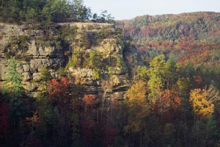
I love the unpredictability of Red River Gorge. An isolated natural hideaway awash with sandstone arches, cascading waterfalls, and sparkling mountain streams, the beauty of the area is courtesy of the frequent rains, snows, and winds of the southeastern climate. Over 25,000 acres of rugged valleys, streams, and mountains nestled in the foothills of the eastern Kentucky Appalachians, the Red River Gorge Geological Area (RRGGA) is a long drive from any interstate highways and a good day’s drive from a major city. Because of this, it is lightly used. Which is why I have this whole spectacular day in the gorge to myself.
This is a land of snow and water, which have combined with erosive effects to sculpt spectacular natural rock formations, including the largest concentration of natural arches east of the Rockies. My favorites are Sky Bridge, offering an expansive view from the trail on top of the span; Rock Bridge straddling Swift Camp Creek; and Grays Arch. Pristine mountain streams splash down the walls and stairs of the gorge into the Red River, part of the state's wild river system. I watch a tumbling rivulet undercut a snowy crust, the fragile edges turning from white to crystal, for a second reflecting the colors of the rainbow, then breaking into the rushing water and bobbing away. The snow is disappearing, Spring recovering from this last skirmish with Winter.
Despite its isolated location in the remote mountainous region of eastern Kentucky, in the early years of this century the gorge was occupied by an army of loggers who cut and shipped the area’s timber. Sawmills and narrow gauge railroads cut and transported the abundant hardwood to eastern markets. Logging camps housed hundreds of loggers and their families. Thousands upon thousands of magnificent oak, hickory, and poplar trees were felled and shipped out of the area and, by the end of World War I, the steep valleys and hillsides of the gorge were left shorn and abandoned. Period photographs show steep, clear cut hillsides with a few forlorn saplings and endless killing fields of ragged stumps.
In the ensuing eight decades, things have changed dramatically. The area became part of what is now the Daniel Boone National Forest in 1937 and the gorge slowly reverted to its natural state, its steep ridges and hollows again teeming with rhododendron, hemlock, wild holly, oak, hickory, and white pine. The sorry impact of the loggers is now hard to see. Their abandoned railroads, sawmills, and houses were overgrown or simply rotted away. The only evidence that remains of the gorge's former role as a logging center is the narrow Nada tunnel near the western entrance to the RRGGA. Carved out of the side of a mountain in 1912 to provide railroad access to the gorge, it now provides hikers, kayakers, and bikers access to the area.
 The Red River Gorge now stands out as one of the most spectacular undeveloped mountainous areas of the eastern United States, something I savor on this cool spring morning as winter slowly loses its grasp on Kentucky. The sun rises to its midday zenith, extending its warming fingers into the bottom of the narrow gorge. The forest undergoes a rapid metamorphosis from blinding crystalline white to dripping verdant green and in a matter of minutes, I am transported into another world. As quickly as it appeared, Winter is gone.
(This article originally appeared in Backpacker Magazine)


0 Response to "Gorgeous Gorge: Kentucky's Red River Gorge"
Post a Comment